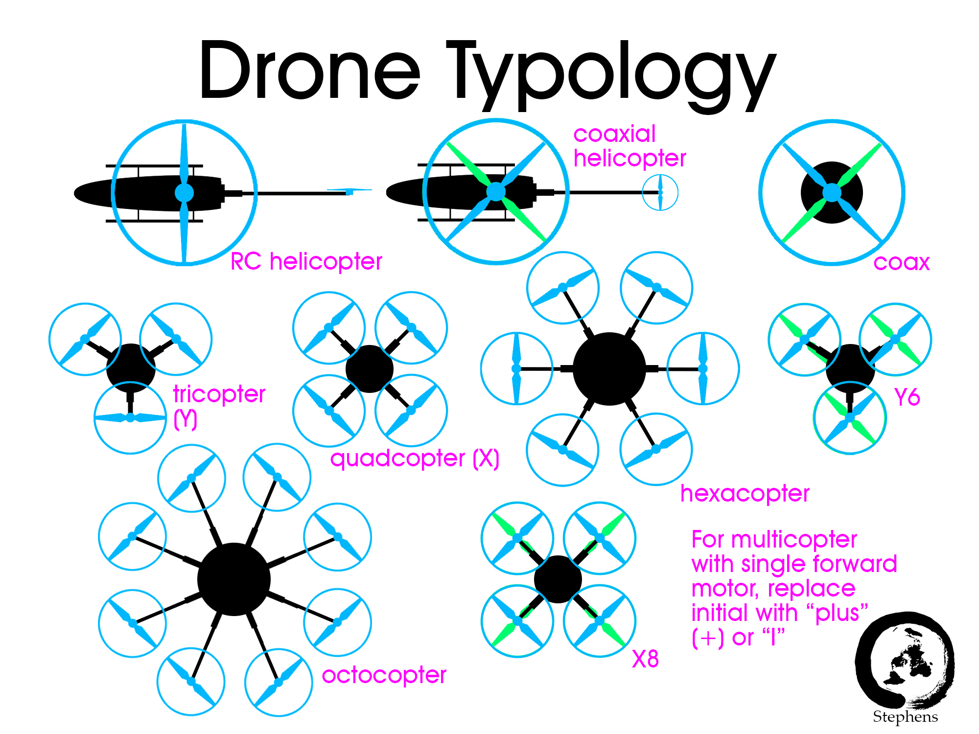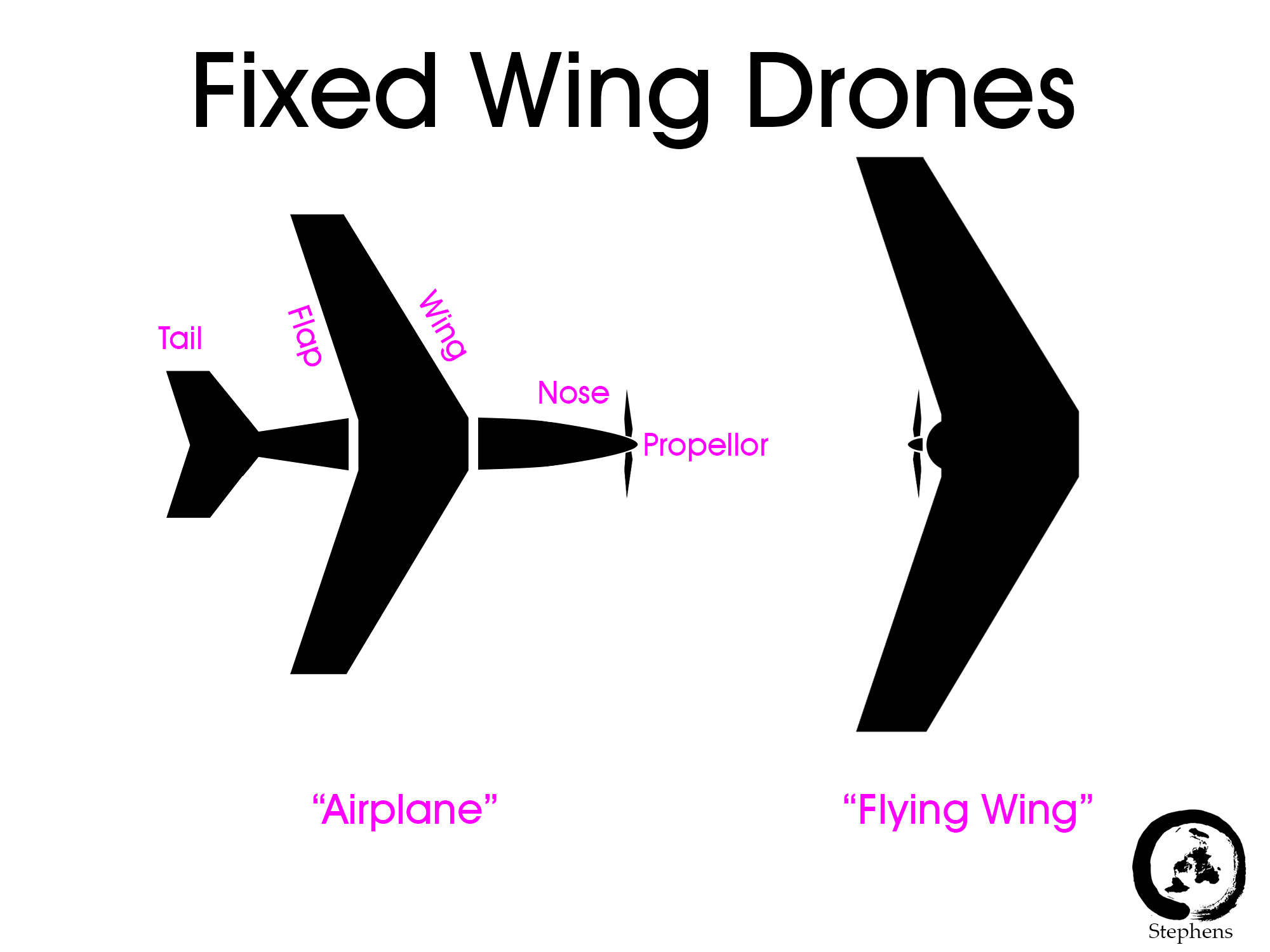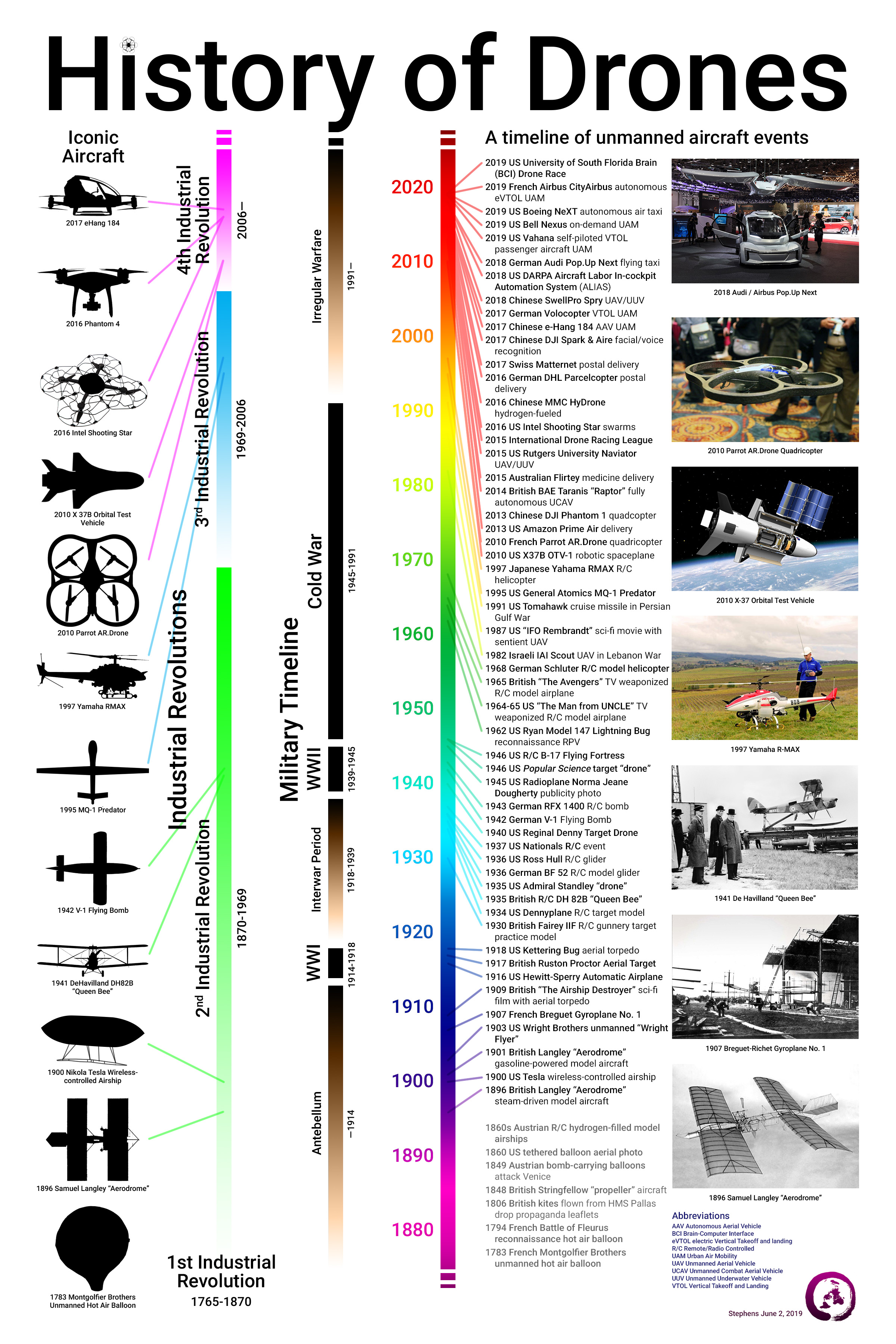
- Advanced Air Mobility Dictionary
- Drones Font
- Emergency Management
- FAA Part 107 Test Resources
- Flight Simulators
- General Reference
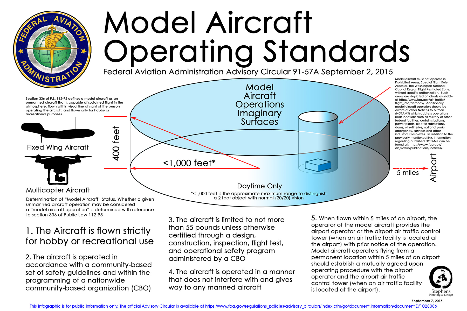
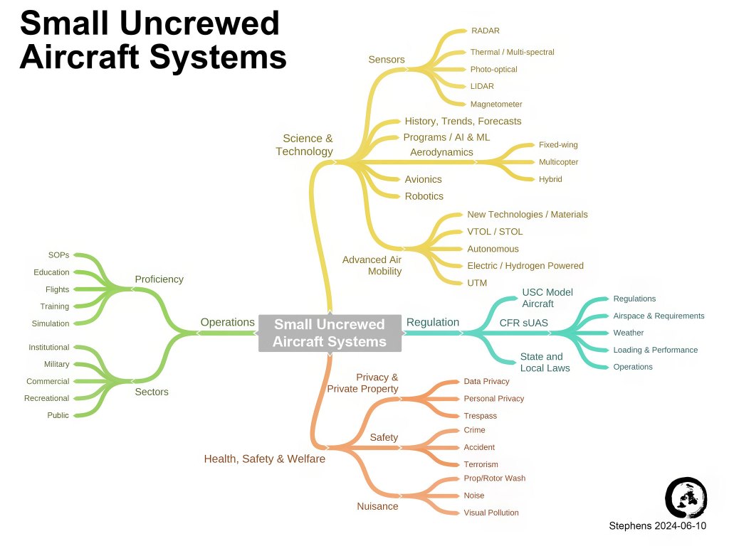
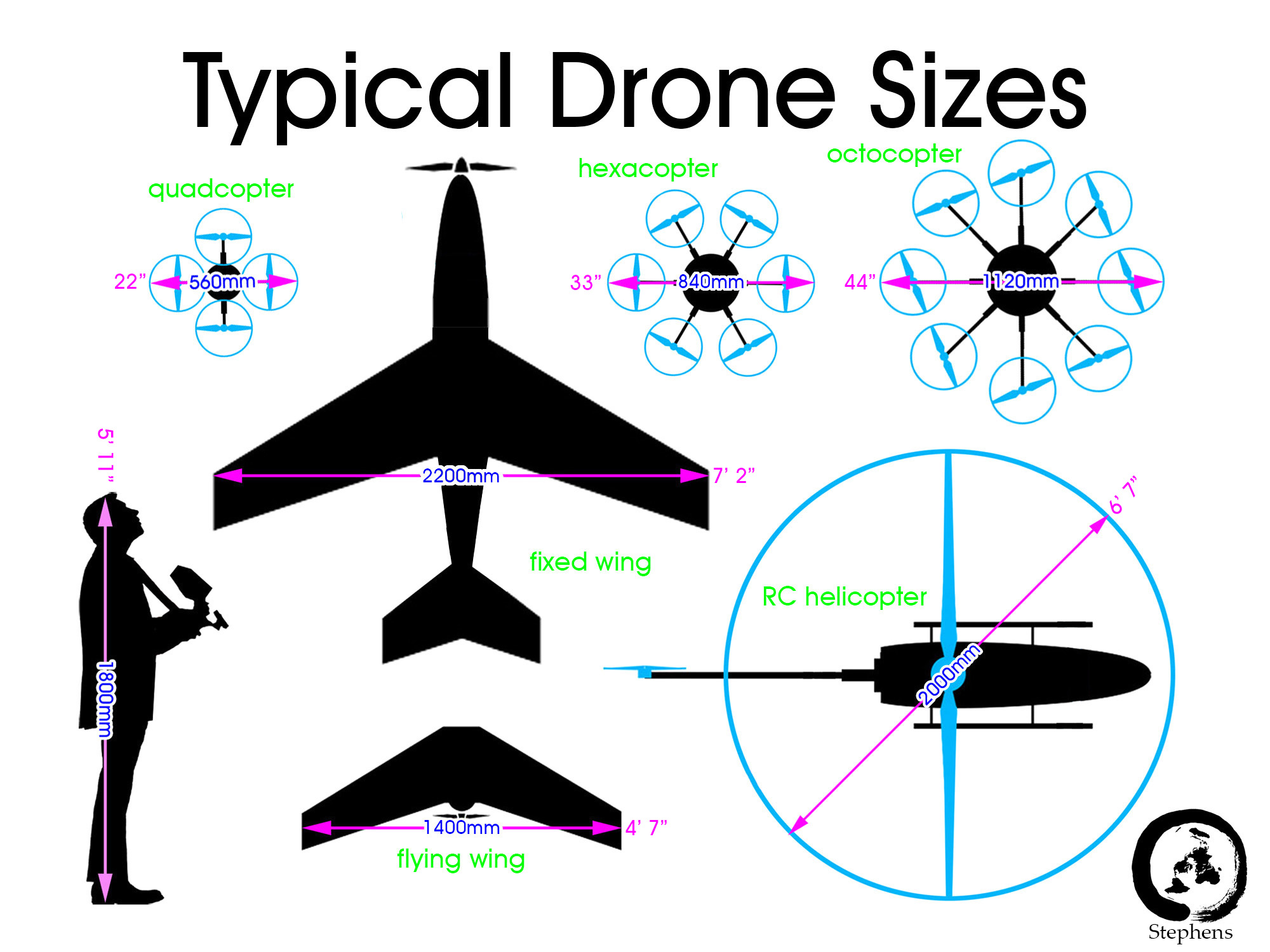
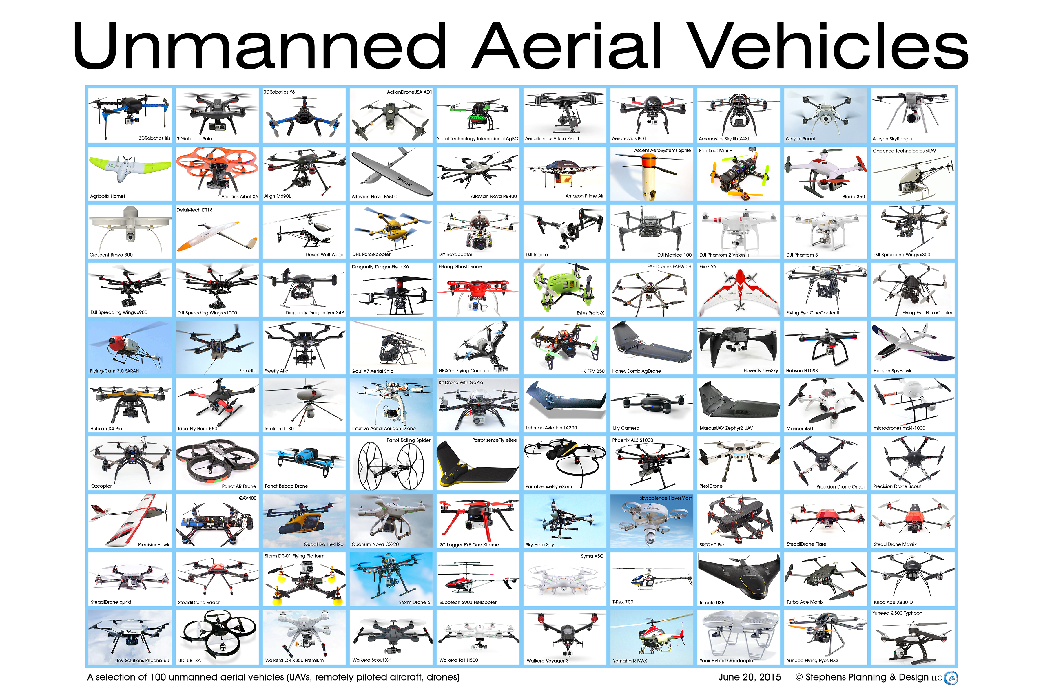
- Infographics
- Mapping and Modeling
- Miscellaneous
- Operations
- Operations Manuals
- Photography/Videography
- Precision Agriculture
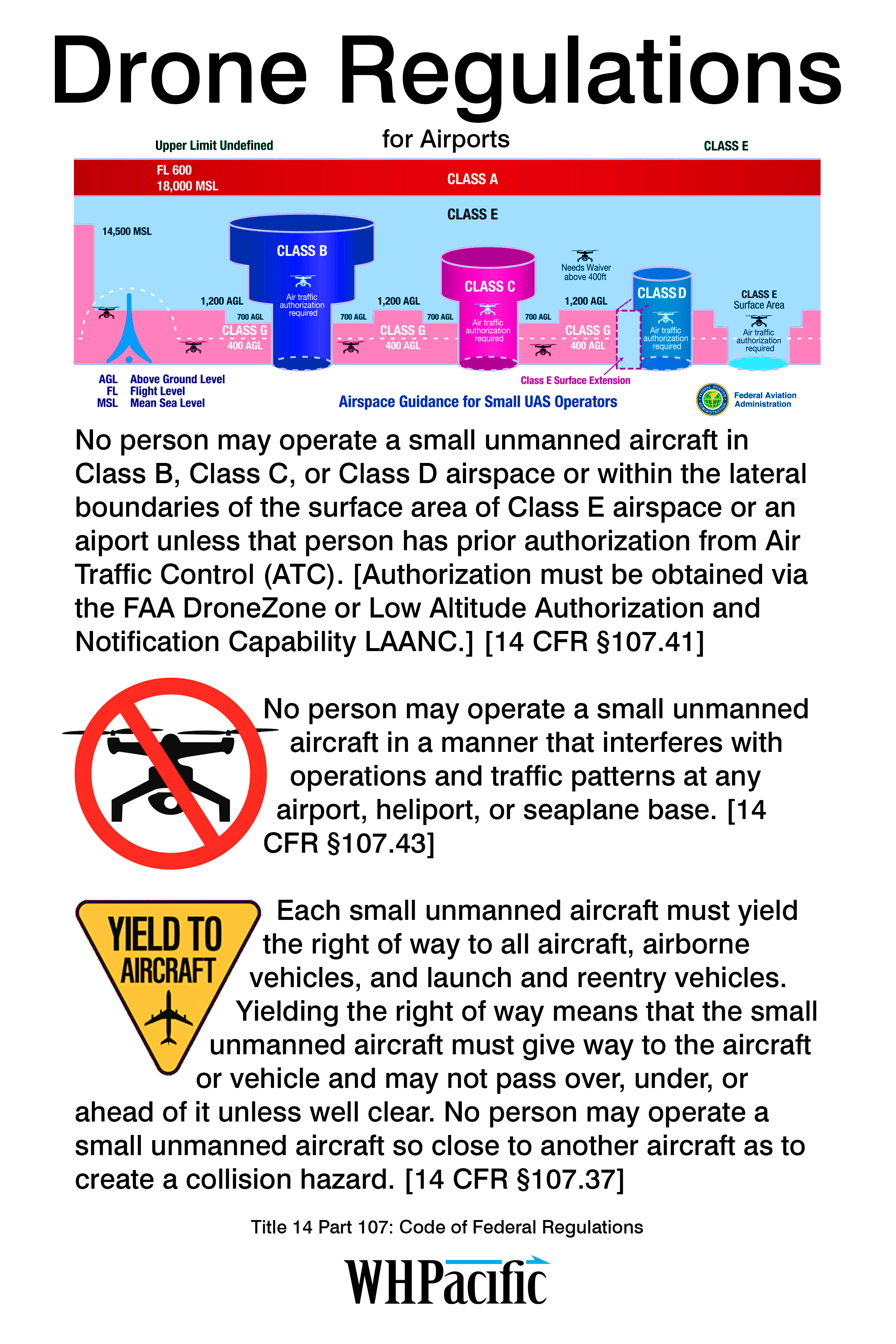
- Regulation
- Weather/Solar
General Reference
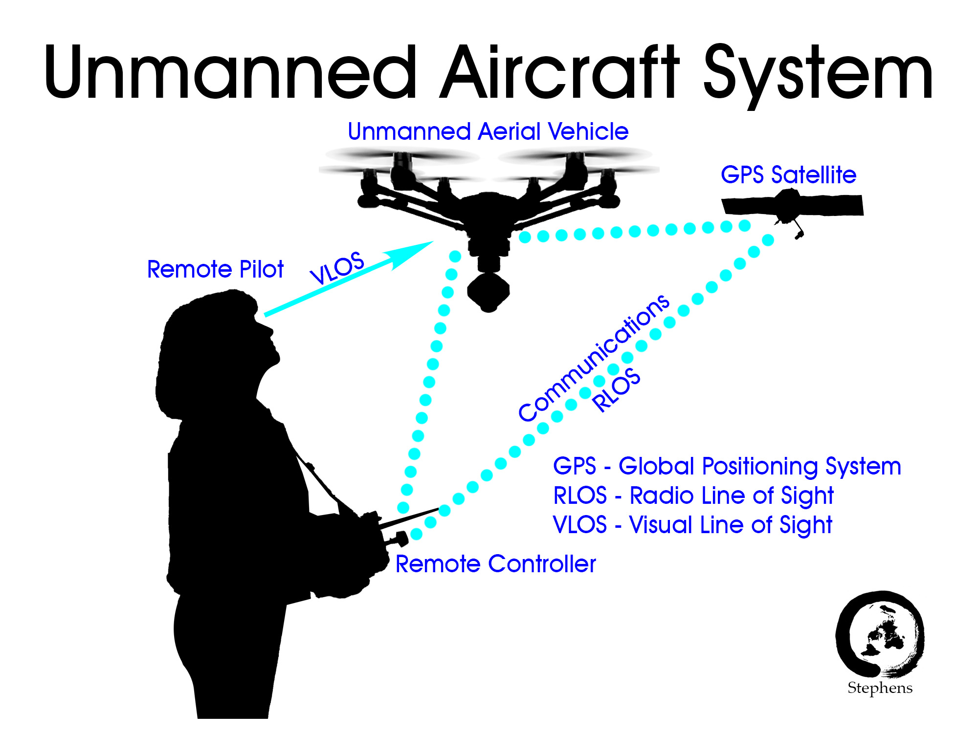
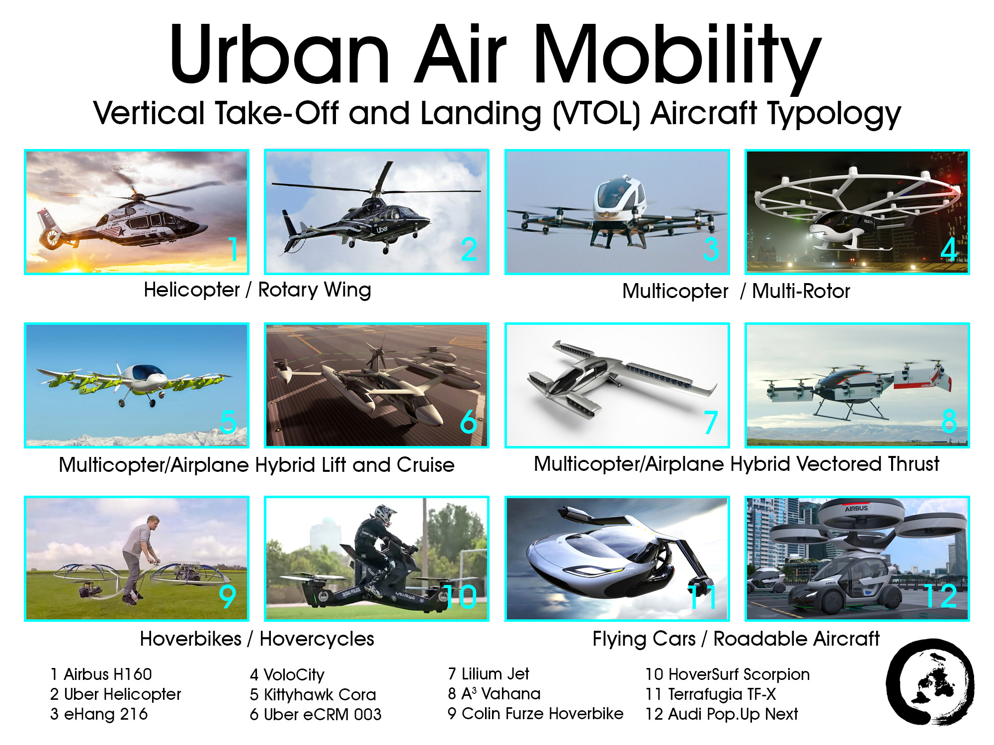
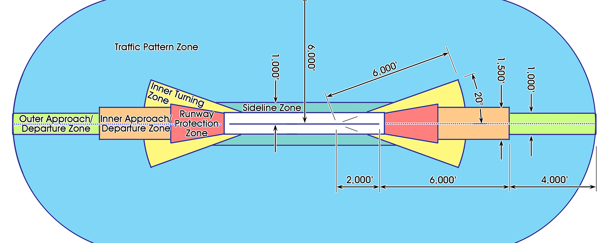
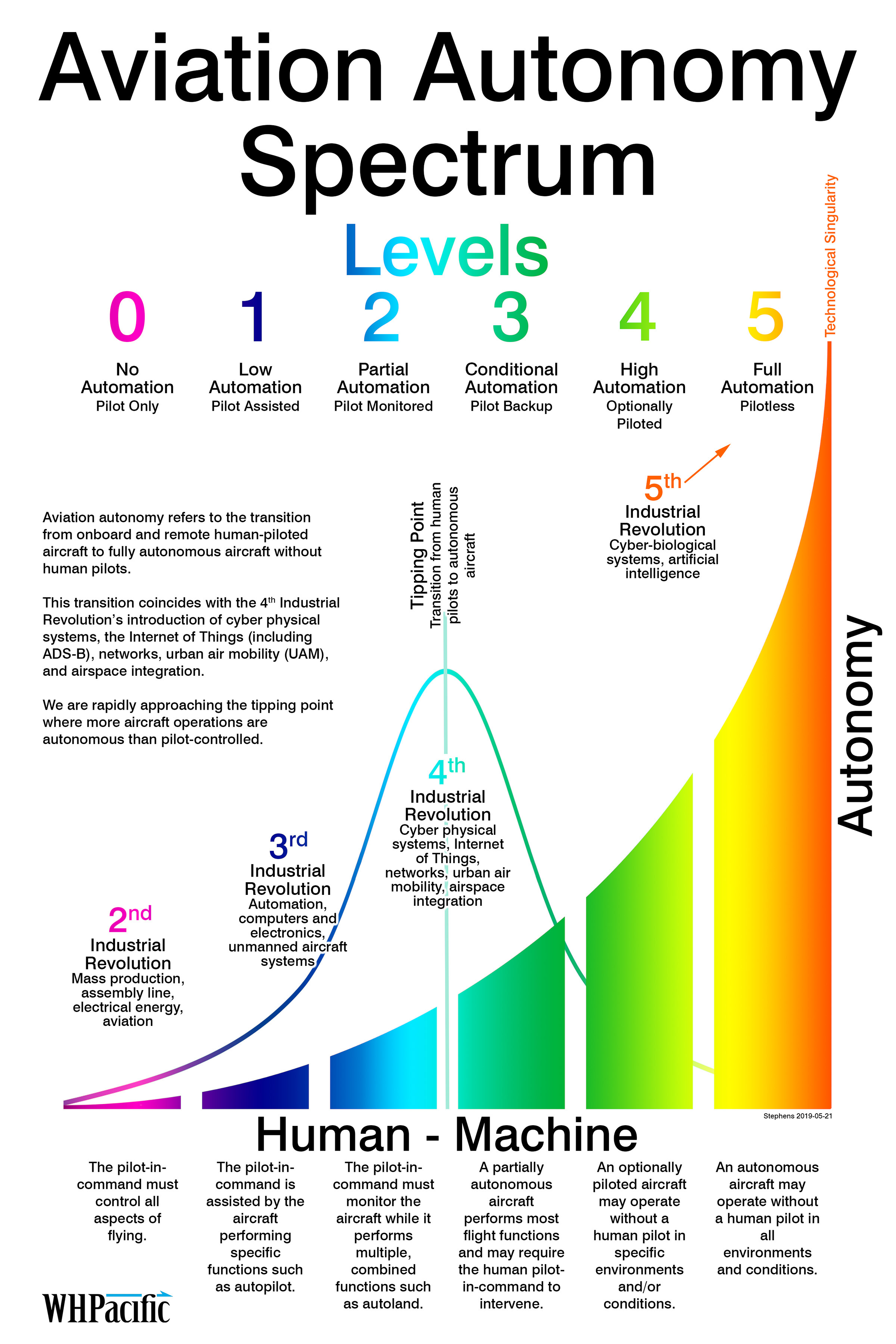
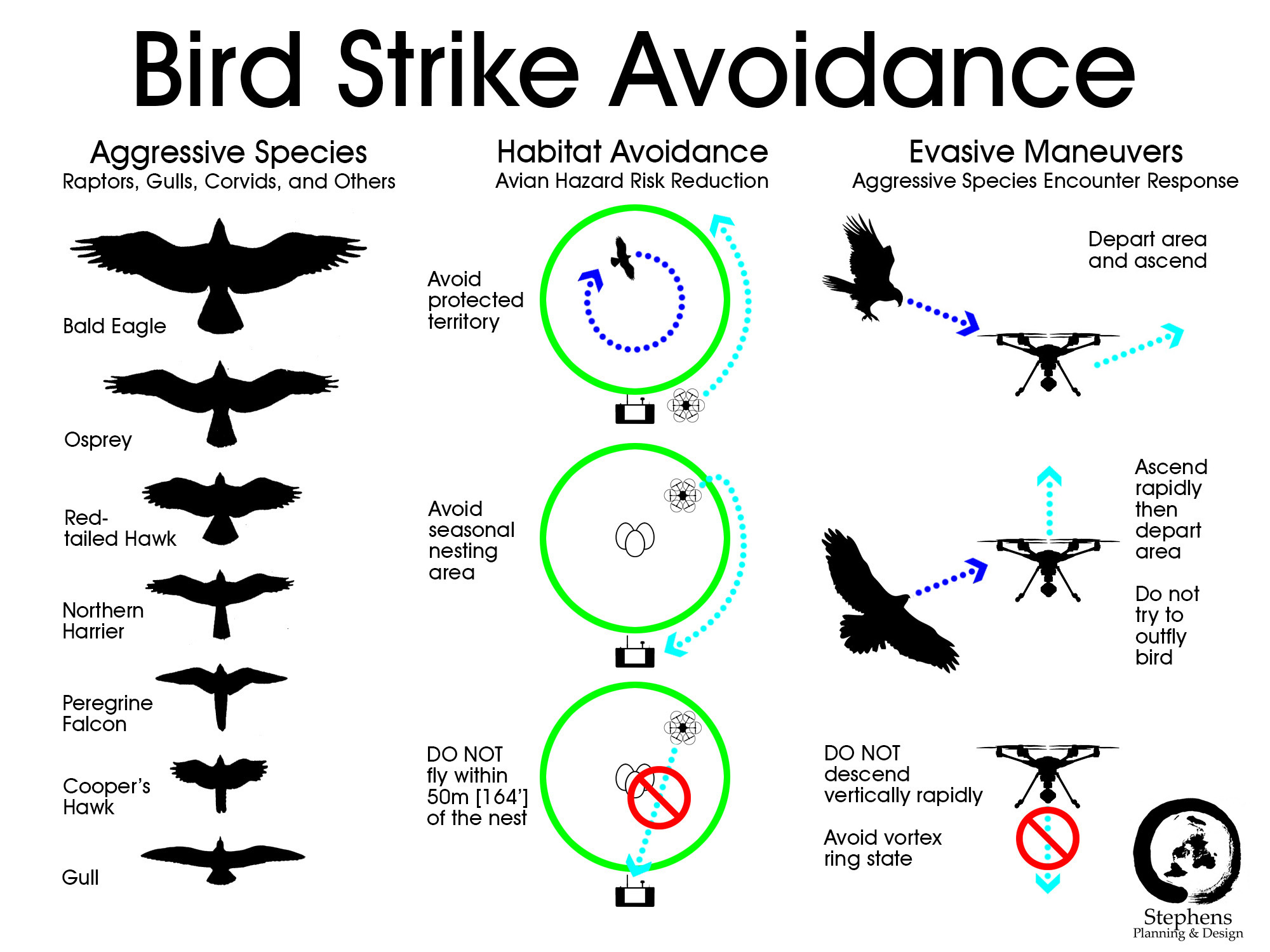
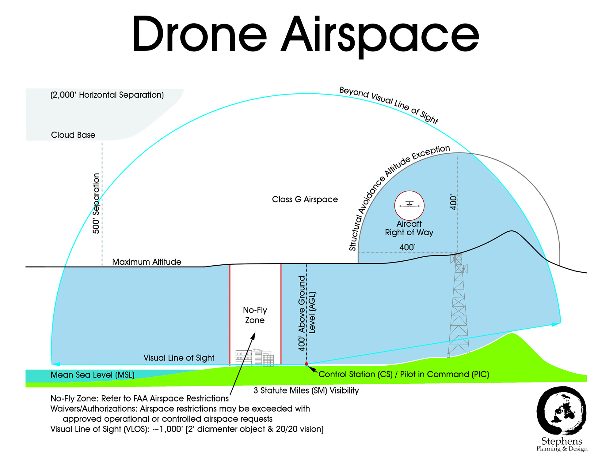
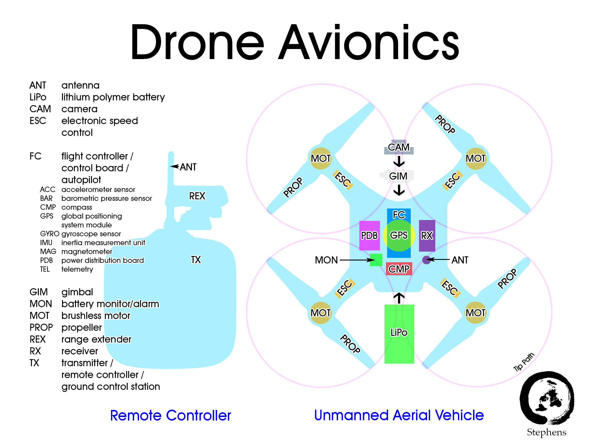
- Advanced Air Mobility Dictionary [pdf] – Abbreviations, glossary, infographics, slang, and international terms relevant to electric conventional takeoff and landing (eCTOL), electric vertical takeoff and landing (eVTOL), urban air mobility (UAM), and uncrewed aircraft systems (UAS) aviation. Formerly the Drone Dictionary. (Stephens) Updated August 28, 2025.
- Autonomous Aviation [website] – Facebook Group for unmanned aircraft systems, urban air mobility, optionally piloted vehicles, and related topics.
- CNAS Drone Database – Database compiled by the Center for the Study of the Drone, showcasing a wide variety of UAS platforms and including their country of origin, manufacturer, endurance, range, payload capacity, speed, and more. (Tyler Roberts)
- Drone Database [Google Sheet] – Database of more than 1,000 uncrewed aerial vehicles. This spreadsheet is currently being updated with blue and green listed aircraft.
- Drone Directory [pdf] – Compilation of 600 small uncrewed aerial vehicles published online June 19, 2022.
- Drone Uses [webpage] – 500+ commercial and institutional applications for UAS
- DroneDJ – DroneDJ is a website that posts news and reviews regarding many of the most popular drones. (Zackary Hilbrands)
- DroneFlyers – “This site is all about helping beginning and intermediate pilots with buying and flying quadcopters and other multirotors.”
- DroneLife – News, products, industries, enthusiasts, business…
- Drones (Popular Mechanics) [Website] – Many features including new technology, drones in science, military use, and more.
- DronesVue – Website with different information tabs such as drone laws, drone safety, photography tips, and more. [Bo Donald]
- Electric VTOL News [website] – “Electric VTOL News highlights the incredible promise and progress of electric and hybrid-electric powered vertical takeoff and landing (eVTOL) aircraft, focusing on non-helicopter VTOL aircraft large enough to carry passengers without conventional helicopter flight controls (though eRotorcraft are now listed as well).”
- P3 Tech Consulting – Creating impactful strategic plans, policies and programs and providing the most up-to-date information on cutting-edge legal-tech issues, with an emphasis on uncrewed aircraft systems including advanced air mobility, urban traffic management, electric vertical takeoff and landing (eVTOL) aircraft, vertiports, uncrewed underwater vehicles and automated driving systems.
- Planning for Advanced Air Mobility – American Planning Association PAS Report 606. Advanced air mobility (AAM) has the potential to impact communities’ access to air mobility, goods delivery, and emergency services in urban, suburban, and rural areas.
- Rotor Drone Pro – Rotor Drone Pro is an online resource for drone enthusiasts and professionals. The website provides a wealth of information on all aspects of drone technology, including news, reviews, and tutorials. Their team of experts offer insights into the latest drone models, accessories, and software. Rotor Drone Pro is also a valuable resource for those interested in drone racing and aerial photography. (Parker Benda)
- sUAS News – “The Business of Drones.”
- UAS Magazine – This is a website dedicated to unmanned aerial systems (UAS) or drones. It provides news, analysis, and insights on the latest trends, technologies, and applications of drone technology across various industries such as agriculture, defense, energy, and transportation. The website features articles, interviews, and product reviews from experts in the field of UAS. It also offers resources such as webinars, events, and directories to help viewers stay up to date and connected with the UAS community. (Parker Benda)
- UAS Pilots Code – Materials for use by aviation practitioners, including UAS practitioners, meant to enhance awareness of safety measures and interaction between manned and unmanned aviation. (Tyler Roberts)
- UAS Weekly – UAS site for news and user forums. (Daniel Webb)
- UAVCoach – Drone training, shopping, guides, and industry news.
- UAV Digest – The UAV digest is a weekly podcast that features in-depth information on all sorts of drone topics. There are over 400 episodes, and each typically focuses on one drone-related subject, so it is easy to find what you are looking for. UAV Digest episodes typically last around thirty minutes. The podcast can be found on its website or any typical podcast platform such as Spotify or Apple. (Zackary Hilbrands)
- Unmanned Aerial Online – Leading online publication that provides up-to-date news, information, and analysis on the unmanned aerial vehicle (UAV) industry. The website covers a wide range of topics related to drones, including drone technology advancements, drone regulations, drone applications, and drone industry trends. It serves as a valuable resource for both professionals and enthusiasts alike who are interested in keeping up with the latest developments in the UAV industry. (Parker Benda)
- Using Drones in Planning Practice [pdf] – American Planning Association (APA) Planning Advisory Service Report 597.
Regulation
- Air Sentinel (app) – Join the innovative network that allows you to detect drones broadcasting Remote Identification (RID) signals flying near you. Air Sentinel is the ultimate drone detection. app, transforming your device into a powerful tool for drone monitoring and airspace awareness.
- Current State Regulations – International drone laws (ICAO)
- Current Unmanned Aircraft State Law Landscape – State Legislation
- Drone Scanner – Transform your phone or tablet into a drone scanner and track all the nearby flights over Direct / Broadcast Remote ID standards.
- European Union Aviation Safety Agency (EASA) – Urban Air Mobility
- European Union Commission Implementing Regulation (EU) 2019/947 of 24 May 2019 on the rules and procedures for the operation of unmanned aircraft
- FAA Drone Zone – Federal registration portal
- FAA Request a Part 107 Waiver or Operation in Controlled Airspace – The FAA will issue waivers/authorizations to certain requirements of Part 107 if an applicant demonstrates they can fly safely under the waiver without endangering people or property on the ground or in the air. First responders and other entities responding to emergency situations may be eligible for expedited approval through the Special Governmental Interest (SGI) process.
- FAA Unmanned Aircraft Systems – Federal Aviation Administration website for UAS regulation.
- Global Drone Regulations Database – This database is comprised of a country directory with summaries and/or links to national drone laws. The objective is to provide humanitarian and non-humanitarian actors with a database of relevant national regulations, additional resources, and links to original regulatory documents to ensure that drones are deployed safely and in compliance with national regulations. (Ethan Curtiss)
- ICAO Unmanned Aviation – International Civil Aviation Organization website for remotely piloted aircraft systems.
- NASA UAM Vision Concept of Operations (CONOPS) UAM Maturity Level (UML) 4
- OpenDroneID OSM – An example receiver implementation for OpenDroneID Bluetooth, Wi-Fi NAN (Neighbor Aware Network) and Wi-Fi Beacon signals for Android phones.
- United States Department of the Interior (US DOI) UAS Fleet – Lists of UAS platforms, payloads, sensors, and software applications that have been approved by the United States Department of the Interior.
- 2018-10-28 UAS White Paper [pdf] Summary and Comparison of Regional Unmanned Aircraft System Policies
Operations
Airspace
- 107Waivers – Online resource for training, resources, and a blog. Contains clear and concise discussions and explanations of FAA laws and waiver types and processes. (Daniel Webb)
- 1800WXBrief – Live charts as well as airport locations and TFRs, also has weather stations with most recent reports. This website is a live chart with all posted TFRs and no fly zones that are kept up to date. It also allows you to check the and find the nearest weather station to you on a map. (Wyatt Hanson)
- Airdata – Integration to allow automatic capture of drone flight and pilot data, maintenance tracking, live stream support, and assistance in meeting compliance requirements. Also includes a data migration program for former Skyward users. (Robert Tyler)
- AIRMAP – Complete situational awareness for drone pilots. Air Map for Drones is a comprehensive platform that provides airspace intelligence, real-time traffic alerts, and automated flight compliance. It assists drone operators in planning safe and compliant flights. (Caleb Kramer)
- Ardupilot – Website for ArduPilot enables the creation and use of trusted, autonomous, unmanned vehicle systems for the peaceful benefit of all. ArduPilot provides a comprehensive suite of tools suitable for almost any vehicle and application. As an open source project, it is constantly evolving based on rapid feedback from a large community of users . Also contains a list of UAS training centers worldwide and a community forum. (Daniel Webb)
- Autopylot – This app is great for mission planning and has great information on weather and airspace. This app also has a built-in feature that tells you if you need special permission to fly in your area. (Jayden Beznoska)
- B4UFLY – The Federal Aviation Administration (FAA) has partnered with Kittyhawk to redevelop B4UFLY, the FAA’s first mobile application, to improve the user experience so that recreational drone operators know where they can and cannot fly.
- CISA UAS Resources – Cybersecurity and Infrastructure security agency. Government website chocked full of resources for UAS pilots and non-pilots concerning the rules and regs of UAS ops in the US. (Daniel Webb)
- DJI Flight Planner – Mission planning, programing DJI drones for altitude and waypoints. (Sydney Duncan)
- Drone Assist – Drone assist is an app that can be downloaded to your phone to use for mission planning. This app integrates weather and hazards that might be present. (Jayden Beznoska)
- Drone Buddy – Drone buddy is an app used for mission planning that includes weather, no fly zones, overall drone news and other cool things going on in the world of UAVs. (Jayden Beznoska)
- Drone Complier – Plan and assign flights around the world, track pilots and gear, customize safety plans and automate your compliance obligations with one tool that goes wherever you fly.
- Drone Harmony – Drone harmony is a software that allows for full 3D mission planning. This software can also automate a flight mission with the correct UAVs. (Jayden Beznoska)
- Drone Up – Provides up to date information regarding airspace restrictions and requirements. It also provides a platform for pilots to communicate amongst each other and the authorities. (Ethan Curtiss)
- Dronedesk – Dronedesk is a great software for drone management. This application allows you to manage clients, log flights, drone maintenance, as well as flight planning with weather and airspace. Free trial. (Jayden Beznoska)
- Dronelab – Dronelab offers a platform for drone pilots and operators to plan, track, and analyze their flights. It provides tools for mission planning, compliance, and reporting, enhancing the efficiency of drone operations. (Caleb Kramer)
- Dronelink – Dronelink is an app focused on safely automating drone missions. The app can automate mapping, cinematography, and more. Features in-depth 3-D previews of the missions that include terrain and buildings. Dronelink is generally only compatible with DJI drones. The app can be used on a browser or downloadable on Android or IOS. (Zackary Hilbrands)
- DroneLogbook – This website is great for logging flights and maintenance as well as scheduling inspections even for a whole fleet of UAVs. Free trial. (Jayden Bezoska)
- FAA UAS Data Delivery System – ARCGIS and Opendata-powered map containing useful information for UAS operators to consult prior to operations. Includes indicators of no-fly zones, operational ceiling heights, airport jurisdiction, and regional data. (Tyler Roberts)
- Flight Radar 24 – shows live feed mapping of commercial airspace vehicles on map. This website is a live chart showing all aviation traffic in the sky on radar. This can be very helpful if you are operating near a busy airspace location and need to know where the nearest aircraft are and if there are any headed in your direction. (Wyatt Hanson)
- Foreflight – Foreflight is a great tool to use for weather, airspace, TFR’s, Landscapes, obstacles, and many other things. Foreflight does require a paid subscription each year of use. (Jayden Beznoska)
- Hover – “The must-have app for drone pilots.”
- Kittyhawk [app] – “Intelligent airspace systems for enterprise UAS operations.”
- LAANC – FAA Low Altitude Authorization and Notification Capability.
- Mapscaping – Live air charts of drone restricted areas. This website is a live chart that shows all posted no drone zones in the U.S. this can be very helpful if you are operating and are not sure of certain airspace in the area. (Wyatt Hanson)
- One Click Drone App – This app is for DJI drones and allows for automated flight planning. This software can program a DJI drone to fly specific waypoints as well as altitudes and airspeeds. (Jayden Beznoska)
- Open Sky – Open Sky is an app that supplies maps, airspace rules, and other regulations. The app allows for flight planning and focuses on helping the user figure out when and where they can fly. This app is free and is available on Android and IOS. (Zackary Hilbrands)
- PrecisionHawk – Precision Hawk provides drone solutions for various industries, including agriculture, energy, and infrastructure. Their platform offers data analytics, flight planning, and regulatory compliance tools. (Caleb Kramer)
- SkyGrid – “Built on AI and blockchain, SkyGrid takes a smarter approach to solving airspace management for drones, air taxis, and other unmanned aircraft.”
- SkyVector Aeronautical Charts – Website mapping for global aeronautical charts and airports.
- UAV Drones Over the USA – Live map of all UAV in operations in USA. This website operates a live map that shows all active UAVs operating that are visible with flight modules and or are visible on radar. This can be helpful if you are not sure if there is another drone in the air near you and can help avoid collisions. (Wyatt Hanson)
- VFRMAP – Digital Aeronautical Charts
Operations MANUALS
UAS Operations GPT – A comprehensive assistant for Uncrewed Aircraft Systems (UAS) operators to design, review, and customize operations manuals, policies, and standard operating procedures aligned with best practices and regulatory standards.
- California Department of Transportation Unmanned Aircraft Systems Operations Handbook (Paul Townsend)
- Chelsea County Emergency Management Unmanned Aircraft System Policy Manual [Fictitious county for training by The Blue Cell LLC] (Olivia Heim)
- City and County of San Francisco Employee Drone Policy
- City of Los Angeles, Department of Public Works, Bureau of Engineering Unmanned Aerial System Flight Operations Manual (Matt Sieverding)
- City of New York Unmanned Aircraft Systems: Impact and Use Policy (Caleb Seuntjens)
- The City of Philadelphia Office of Emergency Management (OEM) Unmanned Aircraft System (UAS) Privacy, Civil Rights, and Data Retention Policy (Justin Heyer)
- Civil Air Patrol sUAS Flight Management (Kyle Clement)
- Colorado Springs Police Department Unmanned Aerial System (Cooper McKenzie)
- Detroit Police Department Unmanned Aerial Vehicles (Caleb Seuntjens)
- Emergency Procedures for Drone Pilots: Safety Protocols and Checklists, DroneBase, (Eric Anderson)
- Los Angeles Fire Department UAS Policy (2019 Revision)
- NOAA Unmanned Aircraft Systems Handbook (Paul Townsend)
- North Carolina Department of Transportation, Division of Aviation, UAS Standard Operating Procedures (Daniel Webb)
- Oregon Department of Transportation Unmanned Aircraft Systems Operations Manual (Daniel Webb)
- Phoenix Police Department, UAS Use Guidelines (Wilbert Werner)
- Pleasant Hill [CA] Police Department Unmanned Aerial System Operations Manual Draft (Matt Sieverding)
- San Diego Police Department Operational Support, Unmanned Aircraft Systems Unit Operations Manual (Bill Schaefer)
- South Dakota Highway Patrol Policy and Procedures Manual [Chapter 17 Small Unmanned Aerial System Operation] (Kyle Clement)
- Texas Department of Public Safety Unmanned Aircraft System (UAS) Standard Operating Procedure ( Bill Schaefer)
- Texas Department of Transportation Unmanned Aircraft System (UAS) Flight Operations and User’s Manual (Sean McManamy)
- U.S Forest Service Standards for UAS Operations (Sean McManamy)
- Wadena County [MN] Sheriff’s Office Unmanned Aerial System Operations (Olivia Heim)
- Washington State Department of Transportation sUAS User’s Manual (Wilbert Werner)
Emergency management
- Airborne Public Safety Association – “To support, promote and advance the safe and effective utilization of manned and unmanned aircraft by governmental agencies in support of public safety operations through training, networking, advocacy and educational programs.”
- Aviation Safety Network – Database containing over 12,000 reports of UAS sightings and airprox incidents involving UAS and manned aircraft, nearly all sourced from official government agency reports. (Tyler Roberts)
- Center for New American Security – Provides resources for the direction of drone development along with providing potential solutions to current and future problems. (Ethan Curtiss)
- DroneResponders – “DRONERESPONDERS is a non-profit program created to unite these new aerial first responders, emergency managers, and search and rescue specialists under a unified organization to help learn, train, and test with one another with the ultimate objective of maximizing drone operations for public safety.”
- Drones for Disaster Planning and Emergency Management [pdf] – A compilation of more than 60 UAS for emergency management applications. The report includes make, model, country of origin, approximate price, brief summary, photo, and weblink for each UAV.
- DroneSense – “We help public safety, government, and critical infrastructure organizations manage life-saving drone programs on one integrated platform.”
- FEMA Unmanned Aircraft System Team – Resource Typing Definition for Response Situational Awareness.
- UAS Emergency Kit Design [pdf] – Comprehensive study on the design of emergency kits for drone delivery in disaster scenarios. It explores the integration of drone technology in emergency management, emphasizing the creation of specialized emergency kits suitable for aerial delivery. The report discusses various aspects including kit contents, drone delivery systems, operational considerations, and challenges. It aims to enhance disaster response effectiveness by leveraging drones for rapid aid deployment.
- UAS Emergency Kit Design Database (Work-in-Progress) [Google Sheet] – Spreadsheet to develop drone-delivered emergency kits for specific disasters.
- UAS Training Exercises for Disaster Response – FEMA/USGS white paper for 5th Federal UAS Workshop
FLIGHT SIMULATORS
- AI Drone Simulator – This is an FPV drone simulator that includes racing and free flight modes. The highlight of this simulator is that the user can add the blackbox files from their FPV drone and the simulator will mimic the flight characteristics of the drone. (Zackary Hilbrands)
- DJI Drone Simulator – “Embrace drone technology as an integral part of work with the DJI Flight Simulator — “DJI FLight Simulator is a professional pilot training software using DJI’s leading flight control technology to recreate the natural flying experience.”
- Drone Racing League Sim – “The DRL Simulator is the most immersive drone racing video game on the console. Featuring the fastest drones, and electrifying racing adventures, it will push the limits of your drone racing abilities and prepare you to fly in real life.”
- droneSimPro – “droneSimPro Drone Simulator is an innovative and affordable flight training software built on the real-world physics of drone flight. Designed for both new and veteran drone pilots, droneSimPro will help you learn the basics and expand your capabilities in flying drones.”
- FPV Freerider -RC Quadcopter Racing Simulator. Practice racing or learn new freestyle tricks without the risk of crashing your real drone.
- Liftoff – “Liftoff is the definitive gateway to the quadcopter racing scene, a platform for both experienced pilots and newcomers to the sport.”
- RealFLight – “RealFlight is the #1 RC flight simulator in the world! It’s the absolute best tool new RC pilots can use when learning how to fly. It also makes it possible for experienced RC pilots to practice new maneuvers and to hone their skills so they can become even better pilots.”
- Simlat -“In a world full of unmanned systems, we provide the most valuable products for training and simulation.”
- TRYP FPV : The Drone Racer Simulator – This drone simulation title features an advanced physics engine that allows the user to get a good grip on the feel of drones. The name suggests it is a racing-focused simulator. However, that is not really the case. TRYP FPV features an in-depth cinematic flight mode where the user can follow various subjects, such as base jumpers or cars, aiming for the perfect shot. Not many drone simulators offer the option to practice high-stakes filmmaking before jumping into the real world. (Zackary Hilbrands)
- VelociDrone – “VelociDrone is a fast paced multi-player and single player FPV drone racing simulator. Using real world racing drones you can fly through an unlimited array of custom tracks with a variety of gates and barriers to hone your racing skills. Some of the gates even move! Our Time attack mode also lets you set the pace and improve with every lap whilst racing against yourself.”
- Zephyr Drone Simulator – “Zephyr is a full-featured training solution and is a highly effective tool for flight academies, commercial enterprises, and anyone seeking practice for safely and efficiently operating unmanned aircraft.”
Mapping & Modeling
- Agisoft – Process digital images and generate 3D spatial data. Fast and highly accurate.
- Coverdrone Flysafe [app] – “Coverdrone FlySafe is a completely free app designed to help our customers plan and conduct their drone flights quicker and safer than before.”
- DJI GS Pro [Ipad app] – “Enhance your drone operations with the DJI Ground Station Pro (DJI GS Pro), an iPad app. Conduct automated flight missions, manage flight data on the cloud, and collaborate across projects to efficiently run your drone program.”
- DJI Terra – DJI Terra is a software suite for drone mapping and modeling. It allows users to generate 2D and 3D models, perform volume measurements, and conduct inspections using data collected by DJI drones.
- DroneDeploy [app] – Drone deploy provides a variety of paid for and free services, from hiring a pilot to training to be a pilot. There are also resources and blogs relating to different fields and topics, such as energy and construction. (Ethan Curtiss)
- Google Earth – Google earth is a great tool for mission planning. This app can give you precise coordinates and show very detailed 3D terrain. There is also measuring tools in the app to find distance between locations. (Jayden Beznoska)
- Hammer Missions – 3D mapping, mostly used for inspections of towers/buildings, Paid Service. (Sydney Duncan)
- Litchi [app] – “Unlock the full potential of your DJI drone with Litchi. With over 4000 successful daily flights, Litchi is the most trusted autonomous flight app for your DJI drone.”
- Map Pilot for DJI [app] – Documentation and articles regarding the use of the Map Pilot app for iOS devices.
- Maps Made Easy -Make your own Orthophoto Maps and 3D Models. No branding. No resolution limits. No subscriptions. Unlimited free processing for small jobs.
- Measure – “Built by commercial drone operators, our platform gives you everything you need to complete automate your drone operations workflow.”
- Open Aerial Map – Open Aerial Map provides an open source platform to share and use drone imagery alongside satellite images. (Ethan Curtiss)
- Picterra -“Geospatial imagery analysis made easy. Train your own AI to detect objects and patterns on satellite and aerial imagery. Analyze and share actionable insights. No coding skills required.”
- Pix4DCapture [app] – Plan and control drone flights using only your mobile phone.
- PrecisionFlight [DJI app] – “Turn your drone into an advanced remote sensing tool.”
- Propeller Aero [app] – Collect, process, and visualize your survey data.
- Raptor Maps [app] – “Artificial-Intelligence (AI) enabled software solution to help solar companies reduce costs and increase energy production.
- Regrid – Shows who owns property/parcels. This website allows you to see who owns what land parcels and or if it is government property. This can be very helpful if you need to contact landowner about anything from accidents/lost drones to getting permission to fly from tm or to see if its government property where flights are not allowed. (Wyatt Hanson)
Photography/Videography
- AirMagic – “Powered by AI and advanced algorithms, AirMagic improves your aerial photos automatically. Simply drag & drop all your pictures to the app, and let technology do the work.”
- Luminar Neo – Luminar Neo drone software is a tool designed for drone pilots and photographers to enhance their aerial imaging. (Trent Hoogendoorn)
- PhotoPills [app] – “PhotoPills is your personal assistant in all photographic matters. It provides tasty remedies to help you answer most of the questions when planning and shooting your creative ideas.”
- Wix – Wix is an aerial photography content creating website, you can edit photos and videos as well as put together 3D models. (Sydney Duncan)
precision AGRICULTURE
- DJI Agriculture – Website providing drone products supporting agriculture and includes a UAS Pilot training to become certified (Bo Donald)
- National Agriculture Aviation Association – NAAA brief and regulations on UAS in the ag sector. (Daniel Webb)
- XAG-Advancing Agriculture – Website with a news center page that contains many updated videos showing how drones are being used around the world. (Bo Donald)
Weather/SOLAR
- Avia Weather – METAR & TAF – This app shows automatically updating and fully decoded METAR, TAF, and NOTAM information for any airport you wish. Non-decoded information can be viewed too. The handiest aspect of the app is that you can set widgets up on your mobile device that allow you to quickly see the information you need without even opening the app. Available on Android and IOS. (Zackary Hilbrands)
- Aviation Weather Center – Weather observation and forecasting, METAR and TAF decoding, SIGMET, G-AIRMET, and WAFS mapping. (Tyler Roberts)
- Density Altitude Calculator – Density Altitude Calculator. This website provided by the weather service allows you to calculate your density weight altitude for your location if you can’t find a reading near you. (Wyatt Hanson)
- Dronecast: Weather and No Fly Zones for Drone Pilots – This app features basic weather information and includes a map that shows flight restrictions. What makes this app unique is that the user can set maximum wind thresholds that relate to the drone limits or user ability. (Zackary Hilbrands)
- METAR & TAF Translator – Copy and paste your raw METAR or TAF text to view color-coded, plain language aviation weather reports.
- Sun Surveyor – This app shows the sunset and sunrise times as well as golden hour and blue hour times. This app also allows you to get a 3D image of your surroundings compared to the sun. (Jayden Beznoska)
- SunCalc – Website for determining sun position and daylight hours.
- Sunrise/Sunset Calculator – FAA reference
- UAS Weather Forecasting – Research Application Lab site providing shared experiences and open dialog about weather and its affects on UAS. Cultivates strategies to progress weather support and Explore opportunities for using UAS-sensed environmental information for enhanced situational awareness and better weather prediction. (Daniel Webb)
- UAV Forecast [app] – Weather and satellite information for UAS operations.
- Weather Report Decoding – METAR and TAF abbreviations.
- Windfinder – Shows wind conditions with live mapping. This website is a great tool to use to be able to visualize wind speed and direction near you along with data from the nearest weather stations. (Wyatt Hanson)
- Windy [app] – Wind map and weather forecasting.
- Wunderground – live weather stations with readings. Is a map view with all weather stations publicly available on it. You can find the one nearest to you and click on it and get the most current weather reports from that station. (Wyatt Hanson)
Miscellaneous
- Association for Uncrewed Vehicle Systems International (AUVSI) – The Association for Unmanned Vehicle Systems International (AUVSI) is a non-profit organization dedicated to advancing the development and use of unmanned systems and robotics. Their mission is to promote and support the advancement of technology, innovation, and policy in the unmanned systems industry. AUVSI serves as a platform for industry leaders, and researchers to collaborate and share knowledge. They offer a range of programs and events, including conferences, webinars, and publications, to facilitate the growth and success of the unmanned systems industry. (Parker Benda)
- DIY Drones – DIY Drones is a community of enthusiasts, makers, and professionals interested in the development and use of unmanned aerial vehicles (UAVs). The website offers a wealth of resources, tutorials, product reviews, and news articles. Users can also find a variety of ready to fly drone kits and components in the online store. (Parker Benda)
- Drone Flight Checklist Pro – This app allows the user to perform preflight checklists and save their flight information. Custom checklists can be added too. (Zackary Hilbrands)
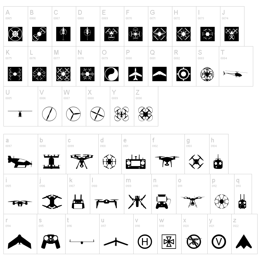
- Drone Font – Free downloadable font with UAS symbols and icons. (Stephens)
- Drone Insurance – “Schedule flight liability coverage for as little as a day or as long as a year.”
- Drone Law Journal – Drone Law Journal is an online platform that provides up to date information on the legal aspects of drone usage. With the rise of drone technology, there has been a need for regulations to ensure safe and responsible use. Drone Law Journal covers topics such as FAA regulations, state and local laws, privacy concerns, and insurance requirements. The platform offers insights from legal experts and industry professionals. (Parker Benda)
- Drone U – Drone U offers online courses, webinars, and resources for drone enthusiasts and professionals. It covers a wide range of topics, from Part 107 certification to advanced flight techniques. (Caleb Kramer)
- Drone Nodes – Information on FPV drone simulators, radio control systems, RC transmitters, and electronic speed controllers. (Bo Donald)
- Drone Scanner [mobile app] – Transform your phone or tablet into a drone scanner and track all the nearby flights over Direct / Broadcast Remote ID standards.
- Drone Racing League – Provides resources for drone racing along with guides for FPV drone flights. (Ethan Curtiss)
- The Dronecode Project – The Dronecode Project is an open-source project that provides a collaborative and shared platform for the development of unmanned aerial vehicle (UAV) software. It aims to accelerate innovation in the drone industry. (Caleb Kramer)
- Drones.io – Description: Droners.io is a platform that connects drone pilots with businesses and individuals seeking drone services. It allows pilots to list their services, bid on projects, and grow their drone businesses. (Caleb Kramer)
- Florida Tech UAS – Florida Tech provides a database filled with resources and articles regarding drones. Resources range from government technical reports to peer reviewed journals. (Ethan Curtiss)
- Global UTM Association (GUTMA) – GUTMA focuses on developing global standards for Unmanned Aircraft Systems Traffic Management (UTM). It brings together stakeholders to address challenges and promote the safe integration of drones into airspace. (Caleb Kramer)
- How to Fly a Drone (Popular Science, November 1946) – This article may be the first time the word “drone” was published. For more information on using B-17 bombers as remotely piloted aircraft, see Operation Aphrodite.
- InterDrone – Website providing information on drone expositions and festivals. (Bo Donald)
- LiveATC.net – Listen to live air traffic control.
- Rotor Riot – Rotor Riot is a leading brand in the world of drone racing. They offer a wide range of products and services to help drone enthusiasts take their passion to the next level. Their website is packed with information on everything from the latest drones and accessories to racing events and competitions. Rotor Riot also produces high quality videos, providing viewers with a unique and thrilling perspective on the sport. (Parker Benda)
- Small UAV Coalition – The Small UAV Coalition is a group of companies dedicated to promoting the interests of small unmanned aerial vehicle (UAV) manufacturers and operators. The organization advocates for favorable regulatory policies that balance safety and privacy concerns with the potential benefits of UAV technology. They work closely with lawmakers, regulators, and others to ensure that regulations are reasonable and effective. The coalition also promotes the safe and responsible use of UAVs by educating the public on the best practices. (Parker Benda)
- Tesla Magnetic Field Recorder [app] – This free app use the magnetometer sensor of your mobile device to transform your phone or tablet into a fun and easy to use metal detector / electromagnetic scanner.
- Trimble GNSS Planning – Global Navigation Satellite System data and maps.
- UAV Coach Community Forum – The UAV Coach forum is a community where drone enthusiasts and professionals can discuss various topics related to drones, share experiences, and seek advice on drone operations. (Caleb Kramer)
- Unmanned Systems Technology – Unmanned Systems Technology (UST) is a rapidly advancing field that involves the development and operation of autonomous vehicles and machines. These systems can perform tasks that are too dangerous, difficult, or time consuming for humans to undertake. UST covers a wide range of applications, including unmanned aerial vehicles (UAVs), unmanned ground vehicles (UGVs), and unmanned maritime vehicles (UMVs). These systems are equipped with sensors, cameras, and other technologies that enable them to navigate, gather data, and perform a variety of tasks. The use of UST has numerous benefits, including increased efficiency, reduced costs, and improved safety in hazardous environments. (Parker Benda)
- WiFi Analyzer – Turns your android phone into a Wi-Fi analyzer. Shows the Wi-Fi channels around you.
- Women and Drones – Website connecting women within the drone industryfrom all around the world with each other. (Bo Donald)
- Youth Drone Sports – This organization provides the youth a chance to get involved in drones or STEM systems at a young age to spark an interest in their future. (Bo Donald)
FAA Part 107 Test Study Resources
- Testing Center – Locate a testing center.
- Airman Knowledge Testing Supplement for Sport Pilot, Recreational Pilot, and Private Pilot – Supplemental book with exam illustrations and maps used with the Remote Pilot sUAS Study Guide and the Part 107 Exam. (FAA)
- FAA Part 107 Small Unmanned Aircraft Systems (sUAS) Initial – FAA test preparation course
- FAA Part 107 Practice Test – This app is a comprehensive tool for Part 107 exam prep, offering topic-based practice sessions, realistic mock tests, and expert explanations. It estimates passing possibilities and is independent of government entities. Users should note subscription terms, but overall, it’s a valuable resource for success with prepping for the Part 107 exam. I used this app to pass the Part 107 test with a 90%. (Trent Hoogendoorn)
- FAA Part 107 Drone Exam Practice Tests – Random test questions and scored answers.
- Free Drone Certification Study Guide: FAA Part 107 sUAS Test (Tony Northrup)
- Free FAA Part 107 Drone Test Study Guide – Answers and Explanations
- METAR Codes Flashcards – Study flascards for METeorological Aerodrome Reports.
- Part 107 – FAA Practice Test – This app is tailored to help users prepare for the FAA’s Part 107 exam. It features up-to-date practice tests covering key topics like airspace rules, weather, operations, emergency procedures, and maintenance. With interactive study modes, realistic sample questions, and progress tracking, users can pinpoint areas needing improvement. The app offers convenient mobile access, mirrors the exam format, provides detailed explanations, and offers personalized study plans. (Trent Hoogendoorn)
- Pilot’s Handbook of Aeronautical Knowledge
- Prepware Remote Pilot – This is an app that allows the user to study for and take simulated exams for the part 107 exam. Uses real questions and includes the testing supplements. Also includes explanations for the answers. This developer also has apps for all other FAA exams. These apps are incredibly useful for exam preparation. (Zackary Hilbrands)
- Prepare for your Remote PIC with sUAS rating (Part 107) (Sarah Nilsson, JD, PhD)
- Prepware Remote Pilot – This app serves as a comprehensive preparation, study, and test tool for the Remote Pilot Initial (Part 107) FAA Knowledge Exam. It provides questions, answers, and explanations for true-to-form practice tests, essential for obtaining your certificate. (Trent Hoogendoorn)
- Remote Pilot sUAS Study Guide [PDF] – The Federal Aviation Administration guide to prepare for the Part 107 Remote Pilot exam. (Use in conjunction with Airman Knowledge Testing Supplement above)
- UAS107 – UAS107, a top-tier app for FAA small drone UAG Remote Pilot exam prep. With over 150 questions and on-demand updates, it ensures users stay ahead with fresh material. Featuring sectional charts, METARS, TAFS, and real-time VFR charts for US airports, it offers comprehensive preparation for exam success. (Trent Hoogendoorn)
- Understanding Airspace for the FAA Part 107 Knowledge Test – Remote Pilot 101
Drones Font
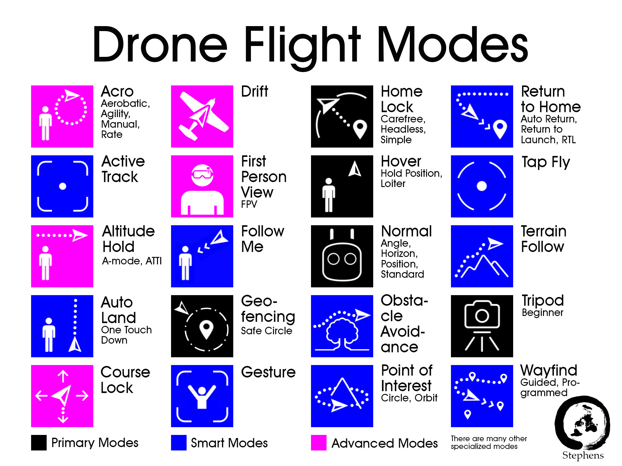
Infographics

Drone Font: https://www.dafont.com/drone-2.font or https://www.1001freefonts.com/drones.font